
The coldest air in the Northern Hemisphere will freeze New England this weekend
A potentially record-breaking cold snap will descend on New England beginning tonight and lasting into Sunday, with wind chills approaching record low levels.
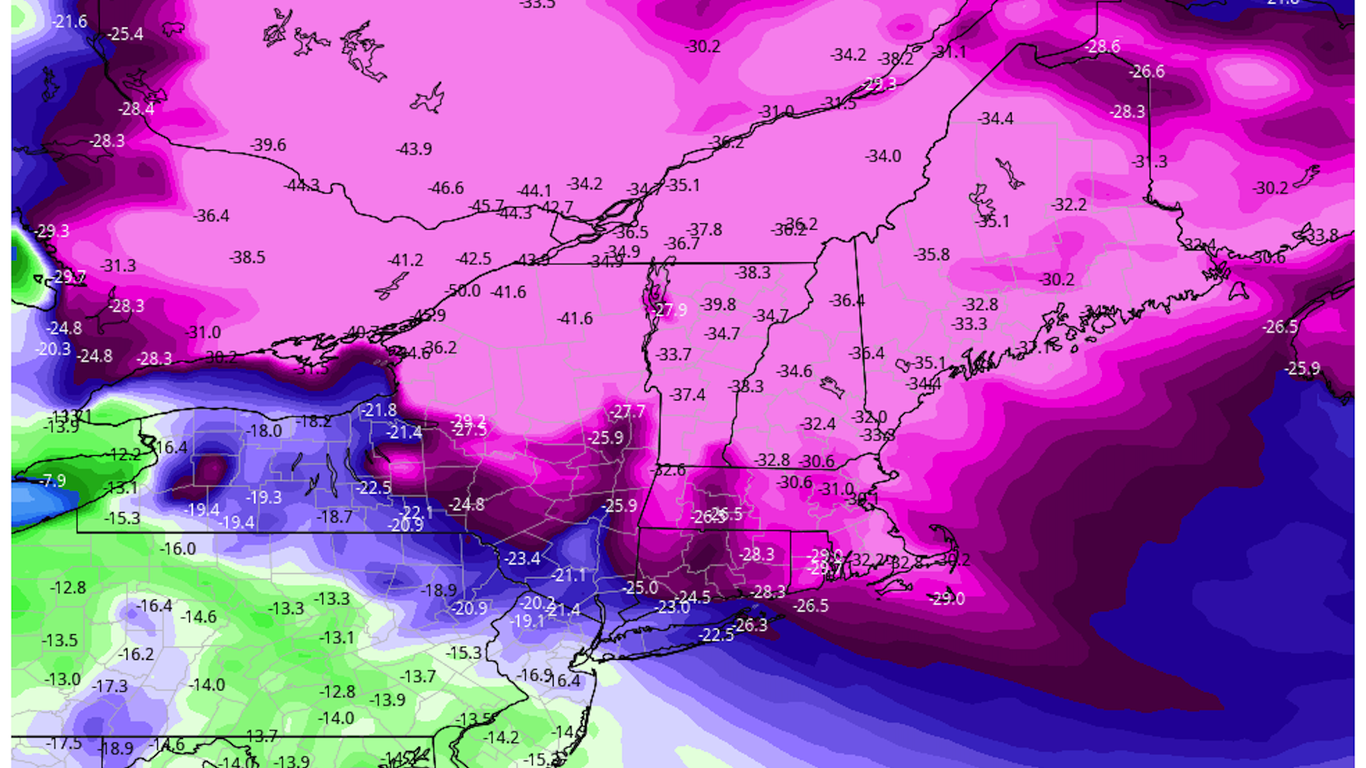
Threat level: With wind chills forecast to reach minus-10°F in New York City, minus-33°F in Boston, and as low as minus-60°F in northern Maine on Saturday morning, the cold could be deadly for anyone caught outside for extended periods.
The big picture: The air mass across northern New England this weekend will be the coldest in the Northern Hemisphere, with the possible exception of a portion of Siberia.
- Wind chill warnings are in effect for parts of New York, Vermont, New Hampshire, Maine, Massachusetts, Connecticut and Rhode Island.
- “The core of the cold will pass over the Northeast and more specifically, northern New England,” the National Weather Service stated in a forecast discussion. “Wind chills into the minus 50s for northern parts of this region could be the coldest felt in decades.”
Threat level: The NWS warns that in such cold conditions, frostbite can occur on exposed skin in 10 minutes or less.
- The winds accompanying the Arctic front could be quite strong, particularly in southern New England, where gusts to 50 mph are anticipated into Friday afternoon and Friday night. At the same time, temperatures will be dropping all day, down into the single digits in Boston by evening, and below zero in northern New England.
- Any power outages could knock out heat during frigid conditions. According to the NWS forecast office in Boston, temperatures there are likely to be comparable to a cold snap in February of 2016, when the city hit minus-9°F. But areas to the north will be far colder.
The cold outbreak comes courtesy of a lobe of the tropospheric polar vortex, which is distinct from the polar vortex that is present at higher altitudes in the stratosphere.
- This region of extreme cold will rotate south from Hudson Bay, accompanied by a powerful cold front with snow squalls and strong winds beginning late Thursday night and Friday morning.
- New York City will miss the core of the cold but will still see low temperatures dip to 9°F above zero on Saturday, with a high struggling to rise into the mid-20s. Wind chills will be below zero, however.
- Philadelphia and Washington, D.C. will also see unusually cold conditions Friday and Saturday.
- Blizzard warnings have been issued in northern Maine due to blowing snow on Friday and Saturday, as winds gusting to 40 miles per hour create what are known as “ground blizzard” conditions.
- The National Weather Service forecast office in Caribou, Maine reports that unofficial records of the coldest air temperatures aloft, as measured by weather balloons, may be in jeopardy.
- “Most stations are forecast to see their lowest wind chills in decades or, in some cases, the lowest ever recorded,” the NWS office in Caribou stated.
- Forecasters at Mt. Washington Observatory in New Hampshire warned in a forecast Thursday night that they may set a new all-time record low temperature during this event. Winds could gust to 140 mph at the summit, and wind chills may plunge to minus-100°F.
- Fortunately, the frigid air intrusion into New England will be short-lived as temperatures are forecast to moderate by Monday.