
Genevieve has been churning up water along Mexico’s Pacific coast since it formed over the weekend, and as the week progresses, tropical downpours and huge swells are in store along its path, as further strengthening is possible.
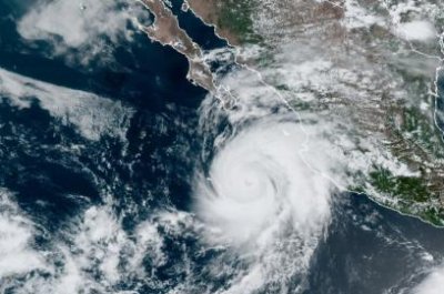
Favorable conditions, including very warm water and weak wind shear in the area, are acting to fuel the monster of a storm. A huge eye was visible on satellite images on Tuesday morning.
Genevieve was born first as Tropical Depression 12-E when it emerged in the warm waters just off the coast of El Salvador and Nicaragua Sunday morning. As a result of the favorable conditions in the area, Genevieve had strengthened to hurricane status just one day later.
In its 12 a.m. Wednesday update, the National Hurricane Center located the storm about 220 miles south-southeast of the southern tip of Baja California, with maximum sustained winds of 115 mph with stronger gusts. It was moving northwest at 10 mph and was forecast to continue this general motion through Thursday as its speed decreases.
“The center of Genevieve is forecast to move near but southwest of the southern portion of the Baja California peninsula tonight and Thursday, and move away from the peninsula on Friday,” the update said.
The storm though downgraded to a Category 3 hurricane is expected to hold its intensity or even strengthen slightly through Wednesday but will steadily weaken after that.
The only other storm to achieve major hurricane status so far in the East Pacific was Hurricane Douglas. Douglas went on to track along the north side of the Hawaiian Islands in the central Pacific during the second half of July, bringing tropical downpours and gusty winds to the island chain.
Genevieve will not take a path similar to Douglas in the coming days, as the storm is expected to bring the bulk of the impactful weather to waters just west of Mexico’s Pacific coast.
Even on relatively tranquil days, the shore break along Mexico’s west coast can feature large waves, posing dangerous conditions for swimmers. As Genevieve churns just off the coast through the week, very large and dangerous swells are expected.
The hurricane’s most significant impact along the coast and waters offshore will be for dangerous surf and heavy seas. Forecasters urge people to avoid the surf and avoid watching the storm from adjacent coastal areas. Large breaking waves can lead to substantial overwash along the coast with the risk of coastal flooding and damage to vessels. Small craft should remain in port and larger ships should avoid the region and the path of the hurricane.
As of Tuesday morning, tropical storm watches were in place across both coasts of the northern part of the Baja California with a tropical storm warning in effect from Los Barriles to Todos Santos, Mexico, in anticipation of a glancing blow from the powerful storm. The tropical storm warning that is in effect includes Cabo San Lucas, a city that is no stranger to tropical activity.
Outer bands of Genevieve will also bring along tropical downpours to coastal cities through the coming days, posing a threat for flash flooding and mudslides. Cities in line to possibly deal with wet weather from Genevieve include Manzanillo and Puerto Vallarta and all areas in-between.
Rainfall from Genevieve’s outer bands can and likely will track into the higher terrain just inland of the aforementioned cities. The mountainous terrain across this region can act to wring out ample amounts of moisture from the atmosphere, enhancing rainfall totals. As this rain funnels into creeks and rivers, towns along their path could face the threat of flash flooding and mudslides.
As the storm continues to parallel the coast, it will begin to track into cooler water off Baja California, into late week. This interaction will undoubtedly begin a weakening trend of the hurricane, but that doesn’t mean the impacts will end there.
The storm’s exact track through this weekend and into early next week is still unclear, but it is possible that some of the residual moisture from the storm could stream into the West Coast of the United States. Along with a potential influx of moisture, increased swells, especially across Southern California, will be possible early next week.