
The increase in the amount of forecast rainfall was due to the storm’s decreased forward speed. Monday night into Tuesday Sally had crawled to a pace of just 2 mph as it inched closer to land.
The storm was already kicking up a significant storm surge in some places along the coastline in Louisiana and caused flooding in Alabama.
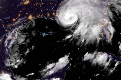
Sally peaked Monday evening as a Category 2 hurricane with maximum sustained winds reaching 100 mph, but the storm lost some wind intensity early Tuesday morning and was downgraded to a Category 1 storm. As of 11 p.m. CDT, Sally had sustained winds of 85 mph.
The eye of the storm was about 65 miles south of Mobile, Ala., and 60 miles southwest of Pensacola, Fla. It was moving north at 2 mph.
AccuWeather’s top hurricane expert Dan Kottlowski said on Monday that some weakening was possible prior to landfall “due to slow movement of the storm causing Gulf waters to cool, an uptick in wind shear and increased friction from the land.”
However, as a consequence of a stalled hurricane just offshore, waves and rain will batter the immediate coast for an extended period with long-duration storm surge flooding.
The hurricane is expected to remain a Category 1 hurricane at landfall along the central Gulf Coast, probably in the panhandle of Alabama early Wednesday morning.
Hurricane Ivan, in 2004, was the last hurricane to make landfall in Alabama. The powerful storm made landfall as a major, Category 3 hurricane on the Saffir-Simpson scale, but was designated as a 4 on the AccuWeather RealImpact Scale for Hurricanes. Ivan is one of only three hurricanes to make landfall in Alabama during the past 31 years, following Hurricane Danny in 1997 and Hurricane Frederic in 1979.
“Despite the weakening in intensity, Sally will still be a significant hurricane strike in the region,” Kottlowski said.
Gulf Coast residents were rushing preparations to completion on Monday as the region braced for another hit from a hurricane — a little over two weeks after Laura’s devastating blow to areas farther west. Forecasters noted that New Orleans will avoid the worst of the hurricane, as was the case with Laura, due to an eastward shift in the storm’s track. The National Hurricane Center discontinued hurricane warnings and then later dropped tropical storm warnings on Tuesday for Lake Pontchartrain, Lake Maurepas and metropolitan New Orleans.
Hurricane warnings were in effect from east of Bay St. Louis, which is located about 50 miles northeast of New Orleans along the Gulf Coast of Mississippi, to Navarre, Fla., which is located just east of Pensacola. Topical storm warnings extend westward along the Gulf Coast to Grand Isle, La., which sits in the far southeastern parts of the state, and eastward to Indian Pass, Fla., a coastal town more than 150 miles east of Pensacola.
Storm surge warnings, which indicate the danger of life-threatening inundation, were posted from the Mouth of the Mississippi River to the Okaloosa/Walton County line in Florida and for Mobile Bay.
Because of the wind, coastal flooding and inland flooding impacts combined, AccuWeather meteorologists have rated Sally a 2 on the AccuWeather RealImpact Scale for Hurricanes.
The AccuWeather RealImpact Scale for Hurricanes is a 6-point scale with ratings of less than one and 1 to 5 that was introduced by AccuWeather in 2019 to rate tropical systems based on multiple impacts, rather than just wind, like the Saffir-Simpson Wind Scale does.
State of emergency declarations have been issued by Louisiana Gov. John Bel Edwards, Mississippi Gov. Tate Reeves and Alabama Gov. Kay Ivey prior to Sally closing in on the region. Mandatory evacuations have been ordered in low-lying areas of Mississippi and Louisiana, including for areas outside of New Orleans levee system. Officials closed Alabama beaches effective at 3 p.m. Monday, and Ivey recommended evacuations for flood-prone areas south of Interstate 10.
AccuWeather meteorologists expect Sally to take a northward turn with a landfall along the coast of Alabama early Wednesday morning. With this more eastward track, concern is increasing for a significant storm surge on Mobile Bay, Ala., and increased surge in Pensacola Bay.
Sally was the earliest named “S-Storm” to ever form in the Atlantic Ocean basin, beating out 2005’s Hurricane Stan which was named on Oct. 2.
In less than 24 hours, Sally went from being a mass of showers and thunderstorms east of the Bahamas on Friday afternoon and to a tropical depression on Friday evening, before becoming a tropical storm on Saturday afternoon.
Torrential rain fell across South Florida as the tropical disturbance passed through. Marathon and Key West, Fla., both set preliminary daily and monthly rainfall records, with 8.13 inches and 9.37 inches falling, respectively, on Saturday.
Impacts from Sally will range from strong winds to heavy, flooding rainfall and dangerous storm surge.
Widespread wind gusts of 40 mph to 60 mph are expected from the central Florida Panhandle to eastern Louisiana. The strongest, and most damaging, winds are likely to be near or east of the anticipated landfall on the immediate coast.
An AccuWeather Local StormMax wind gust of 100 mph is possible near the track of the center of the storm.
Near the center of the storm, and to the east, is also where coastal inundation is expected with Sally.
“The shape of the coast and Mobile Bay is going to put the region at risk for the storm to push a significant amount of water into the area,” said AccuWeather senior meteorologist Alex Sosnowski.
Storm surge of 6 feet to 10 feet is anticipated in eastern Louisiana and along coastal portions of Mississippi and Alabama with locally higher levels possible, while storm surge of 1 foot to 3 feet extends all the way through the Florida Panhandle.
There is also the potential for brief tornadoes and waterspouts to spin up near and east of the center of the storm as it crawls inland. On Tuesday morning, tornado watches were issues by the National Weather Service for coastal Alabama and the western half of the Florida Panhandle.
After moving inland, the storm will lose wind intensity, but continue to pull moisture northward into the Deep South.
Downpours are expected to spread across the interior South into the end of the week with an AccuWeather Local StormMax rainfall of 30 inches near and just northeast of where the center of the storm moves in from the Gulf coast.
“A double whammy with torrential, flooding rain and storm surge flooding that backs up Mobile Bay and the Mobile River are a great concern for the city of Mobile and the surrounding metro area and suburbs,” AccuWeather meteorologist Matt Benz said.
Significant, life-threatening flash flooding is possible due to such high rainfall amounts. Roads may become impassable and some communities may become cutoff from first responders and medical services for a time.
“Rivers will be on the rise in the region, especially in portions of Mississippi and Alabama, where torrential rainfall will spread slowly inland,” Sosnowski said.
AccuWeather meteorologists said that natural gas and oil production is expected to be shut down for one day to two days in the north-central Gulf as Sally moves through the region, but the majority of the rigs are located farther west, over the western Gulf of Mexico.
And Sally wasn’t the only system that meteorologists were busy monitoring on Monday. This was the first time that five tropical cyclones, including Paulette, Rene, Sally, Teddy and Vicky, could be seen swirling simultaneously in the basin since such a phenomenon occurred back on Sept. 10-12, 1971, the NHC confirmed on Monday.
Hurricane season does not officially end until the end of November, and forecasters say that named systems could emerge into December this year.