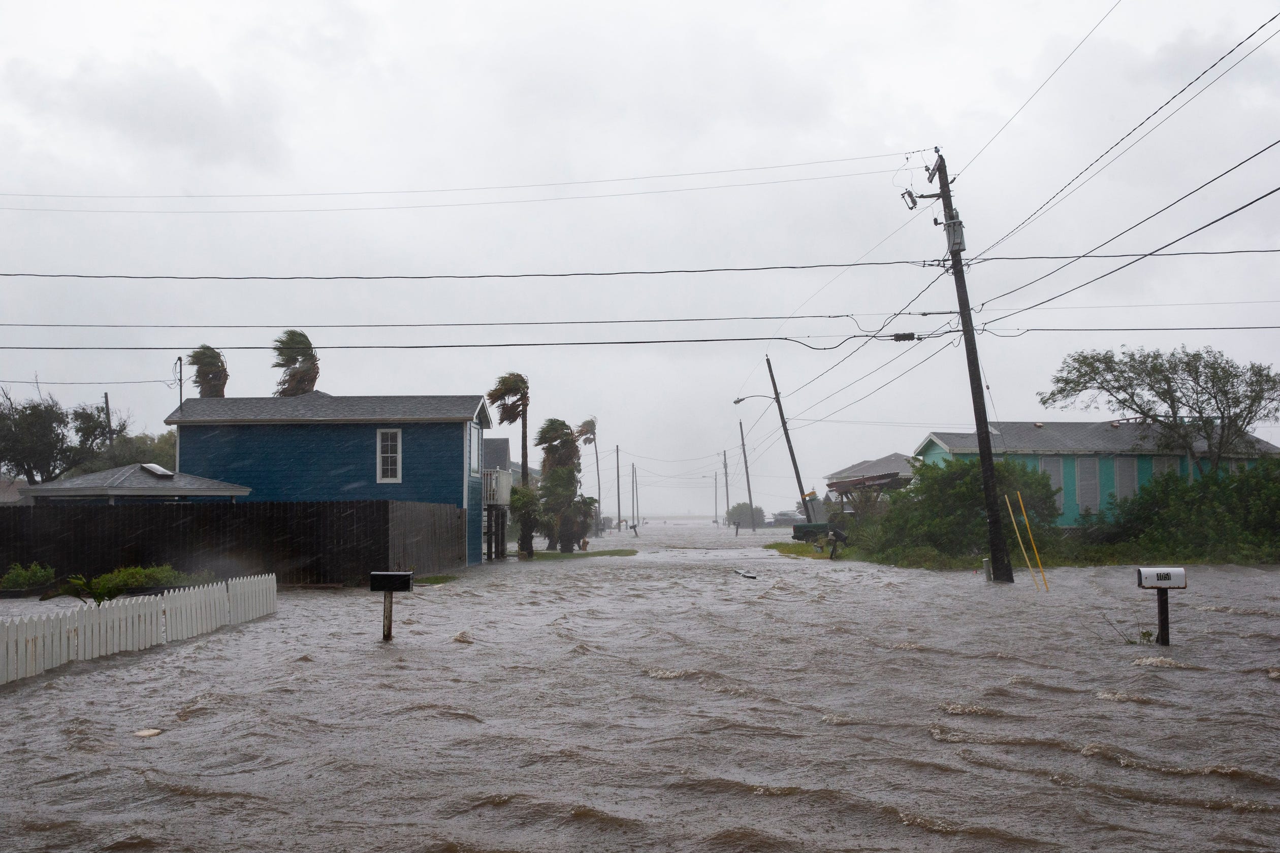


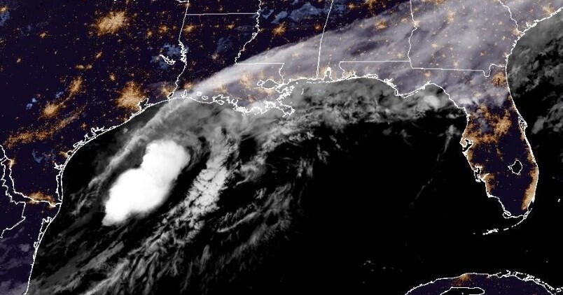
Hurricane Hanna made landfall at 5 p.m. Saturday at Padre Island. The storm was moving west at 8 mph and producing up to 90 mph sustained winds.
Hurricane Hanna is expected to produce 5 to 10 inches of rain with isolated totals of 15 inches through Sunday evening in South Texas.
The western part of the eye of Hurricane Hanna is expected to arrive at 2 p.m., the weather service reported.
The National Weather Service issued a hurricane warning and storm surge warning at 4 p.m. Friday for the Coastal Bend area. The warning states dangerous and damaging winds and life-threatening flooding are possible for the region.
Both warnings are in effect all-day Saturday.
“The storm has slowed down right now as it approaches the coast, but we are expecting heavy rains to pick up as Hanna arrives,” said Eric Forinash, a meteorologist with NWS.
The meteorologist said as of noon Saturday Corpus Christi is reaching 47 mph winds and wind gusts at 59 mph.
The Corpus Christi-area is expected to see winds gusting between 60-75 mph as hurricane force winds and heavy rainfall hit the region.
Hurricane Hanna Tracker: See the storm track on this map as it heads toward Texas landfall
LIVE UPDATES:
10 p.m. Saturday: The American Red Cross opened emergency shelters at H.M. King High School located at 2210 Brahma Boulevard in Kingsville, Tuloso Midway High School’s dome located at 2653 McKinzie Road, and the Pancho Maple Road FEMA Safe Room located at 1001 Pancho Maples in La Feria
9 p.m. Saturday: The Texas State Aquarium will be closed Sunday, July 26 for cleaning due to damage caused by Hurricane Hanna. The aquarium plans to reopen Monday, July 27 from 10 a.m. to 5 p.m.
7:55 p.m. Saturday: A Tornado Warning for Portland, Sinton and Taft was issued until 8:30 p.m., according to the National Weather Service in Corpus Christi.
Tornado Warning including Portland TX, Sinton TX, Taft TX until 8:30 PM CDT pic.twitter.com/QQDrRoPcAv
— NWS Corpus Christi (@NWSCorpus) July 26, 2020
7:46 p.m. Saturday: Art Museum Director Sarah Morgan said the art museum had not flooded, but there was water surrounding the building. Morgan added that more sandbags have been added to the floor and the museum will take the situation hour by hour.
More: Waves crash on Art Museum of South Texas in Corpus Christi
7:33 p.m. Saturday: The National Weather Service in Corpus Christi reported heavy rain from Port Aransas to Portland.
7:16 p.m. Saturday: A Tornado Warning, including Bishop, Texas, was issued until 7:45 PM CDT, according to the National Weather Service.
6:41 p.m. Saturday: Hurricane Hanna made a second landfall at 6:15 p.m. in Kenedy County, Texas, with maximum sustained winds of 90 mph, according to the National Weather Service.
6:38 p.m. Saturday: The National Weather Service in Corpus Christi released a balloon to gather hurricane data.
Suspenseful balloon release into Tropical Storm force winds here at NWS Corpus Christi! Gathering some data for Hurricane #Hanna#txwx#stxwx#HurricaneHannapic.twitter.com/7gaVTYyRpx
— NWS Corpus Christi (@NWSCorpus) July 25, 2020
6:30 p.m. Saturday: Areas near the marina at Flour Bluff and Laguna Shores flooded.
Laguna shores after Hurricane Hanna made land fall south of Corpus Christi #txwx@callerdotcompic.twitter.com/cYcOqLHtD7
— courtney sacco (@Caller_Courtney) July 25, 2020
High water at the marina on Flour Bluff pic.twitter.com/UjokLly20U
— courtney sacco (@Caller_Courtney) July 25, 2020
6:20 p.m. Saturday: AEP Texas requested customers only call the Customer Solutions Center at 866-223-8508 to report downed power lines and safety hazards.
From this point forward, AEP Texas asks that you call the Customer Solutions Center at (866) 223-8508 only to report downed power lines or safety hazards. Please do not call to report an outage for now.
— AEP Texas (@AEPTexas) July 25, 2020
5:32 p.m. Saturday: The National Weather Service in Corpus Christi reported 0.5 to 1.5 inches of rain across Nueces County. Kleberg County received 1.79 inches.
My Administration is closely monitoring Hurricane Douglas off Hawaii & Hurricane Hanna, which has now made landfall in Texas. We continue to coordinate closely with both states — listen to your emergency management officials @Hawaii_EMA & @TDEM to protect your family & property! https://t.co/tFxHLSqcBE
— Donald J. Trump (@realDonaldTrump) July 25, 2020
5 p.m. Saturday: Hurricane Hanna made landfall at 5 p.m. Saturday at Padre Island.
3:32 p.m. Saturday: Nueces County ESD #2 reported severe damage to the end of Bob Hall pier.
2:28 p.m. Saturday: Rockport Police Department announced in a tweet Fulton Beach Road is impassable due to high water and debris on the roadway.
Several roads in Rockport-Fulton are flooded. Officials urge residents to stay off the roads.
Fulton Beach Road is impassable due to high water and debris on the roadway. Please stay off the roads. This is not the day to go and take a drive. #TurnAroundDontDrown
— Rockport Texas Police (@Rockport_police) July 25, 2020
2:19 p.m. Saturday: In a span of two hours, AEP Texas reports 7,717 more customers are without power in Nueces County. There are 16,564 total power outages in the county.
The total outages in the South Texas region are 20,842.
1:54 p.m. Saturday: The National Weather Service reported Hurricane Hanna had strengthened, packing maximum sustained winds of 85 mph. A maximum sustained wind gust was reported at the Laguna Madre, near San Jose.
1:39 p.m. Saturday: The National Oceanic and Atmospheric Adminsitration (NOAA) announced in a news release storm surge will be greatest south of Port Aransas where up to six feet of inundation is possible.
1:06 p.m. Saturday: The National Hurricane Center in Miami reports the eye of Hurricane Hanna is getting closer to the South Texas Coast. Hurricane-force winds are just offshore at Padre Island.
Hurricane #Hanna Advisory 11A: Eye of Hanna Getting Closer to the South Texas Coast. Hurricane-Force Winds Just Offshore Padre Island. https://t.co/VqHn0u1vgc
— National Hurricane Center (@NHC_Atlantic) July 25, 2020
12:48 p.m. Saturday: The city of Corpus Christi reported power outages scattered throughout the city. An outage map run by utility provider AEP Texas showed thousands of customers with no power in central Corpus Christi, the Northside, near Six Points and along Alameda Street. AEP work crews for now are sheltering in place. They aren’t able to safely work in utility buckets once wind gusts reach 35-40 miles-per-hour.
12:44 p.m. Saturday: San Patricio County Judge David R. Krebs signed a Declaration of State of Local Disaster as Hanna became the first hurricane of the 2020 Atlantic Hurricane season.
The county is under a Hurricane Warning until further notice.
12:38 p.m. Saturday: Tornado warning is issued for the Woodsboro and Cranell area. The weather service reports the tornado threat will increase as rain bands from Hurricane Hanna move onshore.
12:36 p.m. Saturday: Aransas Pass Police Department announced in a Facebook post the ferry to Port Aransas has been closed due to wind conditions
12:30 p.m. Saturday: AEP Texas reports 8,847 customers are without power in Nueces County. More than 10,000 power outages have been reported in the South Texas region.
Power outages have also been reported in Port Aransas.
12:11 p.m. Saturday: The city of Corpus Christi announced in a news release the Corpus Christi International Airport has canceled most of its scheduled flights for the remainder of Saturday as Hurricane Hanna approaches the coast.
Flights are set operate at the airport on Sunday. However, it is subject to change depending on weather conditions.
11:30 a.m. Saturday: The city of Corpus Christi addressed the public in a news conference on how it plans to respond to Hurricane Hanna’s arrival.
11:19 a.m. Saturday: The National Weather Service says one of its weather buoys is now in the eye of the storm. It’s located about 60 south-southeast of Corpus Christi. Weather inside the buoy has “dropped dramatically.” It’s the same buoy that became detached during Hurricane Harvey in August 2017.
Buoy 20 is currently getting into the eye Hurricane #Hanna. The pressure has dropped drastically inside the storm.
In case you were wondering: This same buoy was detached during Hurricane Harvey. pic.twitter.com/bv6nTFzLlI
— NWS Corpus Christi (@NWSCorpus) July 25, 2020
10:28 a.m. Saturday: Bus service Saturday through the Corpus Christi Regional Transportation Authority was cancelled. The agency said in a tweet it would restart service on Sunday.
— Corpus Christi Regional Transportation Authority (@CCRTA) July 25, 2020
10:12 a.m. Saturday: Corpus Christi police tweeted it had received reports about flooding at the JFK Causeway and Oso Bridge turnarounds. The agency urged motorists to use caution in the area.
Use caution if you are in the area of the JFK Causeway and OSO Bridge turnarounds. We are getting reports that they are flooding.
— Corpus Christi PD (@CorpusChristiPD) July 25, 2020
9:20 a.m. Saturday: Claire Schroer, an Austin native, talks about her first experience with a hurricane. Schroer was one of many visitors on Port Aransas’ beach Saturday morning as Hurricane Hanna approaches the coast.
9:11 a.m. Saturday: NWS Corpus Christi reports buoy 20 off the Texas Coast is gusting at 63 mph.
9 a.m. Saturday: Incoming tides surge the beaches at Bob Hall Pier. Some park benches can be seen turned on their side.
8:50 a.m. Saturday: Beaches in Port Aransas see rising tides, steady winds and rain as Hurricane Hanna slowly approaches the Coastal Bend.
8:33 a.m. Saturday: A storm surge reaches past the sand dunes near Whitecap Beach. The weather service reports it could soon threaten Highway 361 on Padre Island.
8 a.m. Saturday: Nueces County ESD #2 shares a post on its Facebook page showing tides rising above 4 feet at Bob Hall Pier.
7 a.m. Saturday: Hanna was upgraded to Category 1 status becoming the first hurricane of the 2020 Atlanta hurricane season.
As Tropical Storm Hanna approaches, the tide at at Bob Hall Pier continues to rapidly rise above the predicted level. At this time tides are roughly 3.5 ft above the predicted tide! #txwx#stxwxpic.twitter.com/dirpxvPca5
— NWS Corpus Christi (@NWSCorpus) July 25, 2020
5:41 a.m. Saturday: Tides at Bob Hall Pier begin to rise roughly 3.5 feet above the predicted tide, according to the National Weather Service in Corpus Christi.
What can residents expect?
Residents can expect heavy flooding and tropical-like thunderstorms throughout the day Saturday.
Swells generated by Hurricane Hanna are expected to increase and affect much of the Texas and Louisiana coasts during the next few days. These swells are likely to cause life-threatening surf and rip current conditions.
Harness said storm surge areas could expect two to four feet of water above ground level.
“It’s just important to pay attention to local officials as Hanna moves into the region,” Harness said. “The rain is going to be a big concern and it could lead to flash flooding across the area.”
The City of Corpus Christi has extended its customer call center hours to 24-hours so residents can contact the city’s operations for downed tree limbs throughout the weekend. Residents are encouraged to call 361-826-2489.
Nueces County is urging residents to call its help line 361-414-6000 for any questions on emergency operation and or to report damage from the storm.
Worried about flooding?See what roads are prone to flooding in Corpus Christi
What if the power goes out?
AEP Texas will have additional crews from other areas to help restore power after the storm passes, according to a news release sent by the agency Friday.
During the storm, customers are asked not to call the AEP Customer Solutions Center except to report drowned power lines and other situations that could pose a safety threat. To report a fallen power line or utility poll, call 1-866-223-8508.
Residents can track progress on the restoration effort by visiting the outage area at www.aeptexas.com.
What are the latest weather alerts?
A Hurricane Warning is in effect from Port Mansfield to Mesquite Bay, National Weather Service in Corpus Christi reported.
A tropical storm warning is also in effect from Mesquite Bay to High Island.
A flash flood watch was also issued for parts of several South Texas communities, including Nueces, Bee, Jim Wells, Refugio and San Patricio counties. It expires Sunday night.
STORM COVERAGE:
Know the terminology: Hurricanes, storms, depressions
Amid COVID-19 crisis, hurricane season brings new challenges
Hanna is ‘steadily strengthening,’ expected to become hurricane before landfall Saturday
Tropical Storm Hanna: Corpus Christi, Nueces County officials warn residents to stay home
Meagan Falcon covers entertainment, things to do and trending news. Support more coverage like this by checking out our subscription options and special offers at Caller.com/subscribe
Autoplay
Show Thumbnails
Show Captions
Read or Share this story: https://www.caller.com/story/news/local/2020/07/25/hurricane-hanna-live-updates-tropical-storm-texas-gulf-coast-corpus-christi/5494915002/


